

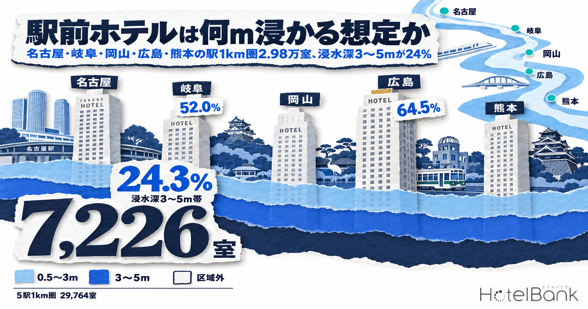
We overlaid the coordinates of 254 operating hotels with 29,764 rooms within 1km of five stations — Nagoya, Gifu, Okayama, Hiroshima and Kumamoto — on the flood inundation zones (maximum assumed scale) published by the Ministry of Land, Infrastructure, Transport and Tourism (MLIT) Real Estate Information Library. Only one room sits outside the zones. 75.2% of rooms (22,371) fall in the 0.5–3m inundation-depth band and 24.3% (7,226) in the 3–5m band; at Hiroshima Station 64.5% of the 1km-ring rooms are in the 3–5m band, and at Gifu Station 52.0%. This article treats inundation depth not as “a reason to avoid investing” but as a design condition — “which floor should the substation, emergency generator, boiler, kitchen and front desk go on?” — and quantifies, station by station, the extra investment per room, the flood rating class used in fire insurance, which bands the supply opened since 2020 sits in, and which bands planned projects fall into.
Metric Definitions Used in This Article
- ADR (Average Daily Rate): An estimated contracted rate (tax-excluded equivalent), calculated by applying a segment-specific adjustment factor to the lowest plan level each property publishes on OTAs (per room, 2 guests per room, tax included). Checked against property-level results disclosed by listed hotel REITs (91 properties, latest 3 months), the median error is about 7%. These are estimates and differ from each property’s actual contracted rates and accounting figures. Area-level ADR is the median of the target properties (the level of a typical property in the area). This article uses the October 2025–September 2026 average (12 settled months) and September 2026 alone; N= is the number of target properties in that month.
- Inundation-depth band: The inundation-depth rank of flood inundation zones (assuming the maximum conceivable rainfall) designated and published by river administrators under the Flood Control Act. Ranks are grouped into under 0.5m / 0.5–3m / 3–5m / 5–10m / outside the zones; where zones of multiple rivers overlap, the deepest rank is used. Each property is judged at one representative coordinate; ground elevation, first-floor height and flood barriers are not considered. Properties whose band changes when the coordinate is shifted by 20m are counted separately as “near a band boundary.”
- Target properties: Properties within a 1km radius (2km for comparison) of each station’s representative coordinate whose sales on major booking sites were confirmed from July 2026 onward. Listed room counts are used; properties with no room count were excluded (one at Nagoya Station).
- Data sources: MetroEngines Research & Consulting (properties, room counts, ADR); MLIT Real Estate Information Library (flood inundation zones, official land prices); General Insurance Rating Organization of Japan (flood rating classes); MLIT Building Construction Dynamics Statistics (planned projects).
- — One room outside the zones: Of 254 properties and 29,764 rooms within 1km of the five stations (sales confirmed from July 2026), only one room lies outside the maximum-scale flood inundation zones. 75.2% (22,371 rooms) are in the 0.5–3m band and 24.3% (7,226 rooms) in the 3–5m band.
- — 3–5m band: 64.5% at Hiroshima, 52.0% at Gifu: Nagoya (98.7%), Kumamoto (99.9%) and Okayama (78.5%) are mainly in the 0.5–3m band. The depth in front of Gifu Station is set by the Kiso River scenario, not the Nagara River.
- — New supply sits in the same bands: The 3–5m share of the 78 properties / 8,477 rooms opened since 2020 is 23.2%, almost the same as the 24.5% of those opened in 2019 or earlier (165 properties / 21,212 rooms).
- — Capex to put equipment on upper floors: ¥290k–¥1.03M per room at 150 rooms (editorial estimate): ¥290k–¥670k in the 0.5–3m band, ¥450k–¥1.03M in the 3–5m band — equal to 26–120 room-nights at the ward’s estimated contracted ADR (October 2025–September 2026 average).
- — Three stations sit in flood rating Class 5: Nagoya’s Nakamura Ward, Gifu City and Kumamoto’s Nishi Ward are Class 5, Okayama’s Kita Ward Class 4 and Hiroshima’s Minami Ward Class 3. The planned 177 rooms in front of Okayama Station and 300 rooms in Nodaya-cho fall in the Asahi River’s 0.5–3m band.
Executive Summary — Of 29,764 Rooms Within 1km of 5 Stations, 1 Lies Outside the Zones and 7,226 Are in the 3–5m Band
The findings boil down to three points. First, the areas in front of all five stations should be designed on the assumption that they flood in a maximum-scale event; rooms outside the zones barely exist. What differs is not “whether it floods” but “how deep”: Nagoya (98.7%), Kumamoto (99.9%) and Okayama (78.5%) are mainly in the 0.5–3m band, while the 3–5m band holds the majority at Hiroshima (64.5%) and Gifu (52.0%). Second, 5,012 (69.4%) of the 7,226 rooms in the 3–5m band are in properties with 150 rooms or more. For mid-to-large properties on high-voltage power, where the electrical equipment sits ties directly to asset value — yet spread across the rooms, the extra investment per room becomes thin. Third, the depth-band mix of the 78 properties / 8,477 rooms opened since 2020 is almost the same as earlier supply (3–5m share 23.2% vs 24.5%); new supply has not chosen shallower bands. The location value of being in front of the station has evidently taken priority over inundation depth.
Methodology — Station Coordinates, Target Properties and Publication Dates of Each River’s Zone Map
Station coordinates were used after confirming each address (Meieki 1-chome, Hashimoto-cho 1-chome, Ekimoto-cho, Matsubara-cho, Kasuga 3-chome) with the Geospatial Information Authority of Japan (GSI) reverse geocoder. Target properties are limited to those within a 1km radius (2km for comparison) of each station whose sales on major booking sites were confirmed from July 2026 onward; properties without confirmed recent sales (241 within the five 2km rings) were excluded because they cannot be confirmed as operating. Listed room counts are used, and the one property with no room count (Nagoya Station) is also excluded. Inundation depths come from the MLIT Real Estate Information Library flood inundation zones (maximum assumed scale), retrieved in October 2026; the depth rank of the zone containing each property’s representative coordinate was used. Where zones of multiple rivers overlap, the maximum rank is used, in line with municipal hazard-map practice of overlaying each river’s map and taking the deepest scenario.
| Station | Ward / city | Rivers whose zones overlap the ring | Maximum-scale zone map (main rivers): designation / publication | 1km ring properties / rooms |
|---|---|---|---|---|
| Nagoya Station | Nakamura Ward, Nagoya, Aichi | Shonai River system (Shonai, Yada, Kanare rivers) | Designated Dec 2016, revised Mar 2020 (Shonai River Office) | 92 / 12,621 |
| Gifu Station | Gifu City, Gifu | Kiso, Nagara, Sakai rivers | Published Dec 22, 2016; partially revised Apr 24, 2020 (Kiso River Upstream Office) | 20 / 1,946 |
| Okayama Station | Kita Ward, Okayama, Okayama | Asahi, Hyakken, Takahashi, Sasagase rivers | Designated Apr 19, 2017; revised Dec 10, 2020 (Okayama River Office) | 55 / 6,015 |
| Hiroshima Station | Minami Ward, Hiroshima, Hiroshima | Ota, Old Ota, Motoyasu, Fuchu-Ogawa rivers | Designated Apr 19, 2017; revised Mar 30, 2020 (Ota River Office) | 69 / 7,627 |
| Kumamoto Station | Nishi Ward, Kumamoto, Kumamoto | Shira, Tsuboi, Iseri rivers | Published Mar 29, 2019; revised Dec 24, 2024 (Kumamoto River & National Highway Office, Kumamoto Prefecture) | 18 / 1,555 |
Note that the planned-scale zone maps (roughly 1-in-100 to 1-in-200-year probability) and inundation duration are not distributed by the Real Estate Information Library, so this article covers the maximum-scale scenario only. Checking for zones that stay flooded for more than 72 hours is discussed later as a due-diligence item, using the inundation-duration maps published by each river office.
Room Mix by Inundation-Depth Band at the 5 Stations — 64.5% in the 3–5m Band at Hiroshima, Nagoya and Kumamoto Concentrated in 0.5–3m
Stacking the rooms within 1km of each station by depth band makes the differences between the five stations clear at a glance. At Nagoya Station (12,621 rooms) and Kumamoto Station (1,555 rooms), almost all rooms are in the 0.5–3m band, with none in the 3–5m band. At Okayama Station 1,291 rooms (21.5%) are in the 3–5m band, while at Hiroshima Station (4,923 rooms, 64.5%) and Gifu Station (1,012 rooms, 52.0%) the 3–5m band dominates. The 3m boundary corresponds to the height of the second floor, and it also divides bands where ground-floor equipment can be protected by raising it from bands where it must be moved to the second floor or above.
| Station (1km ring) | Properties | Rooms | Outside zones | Under 0.5m | 0.5–3m | 3–5m | Near a band boundary |
|---|---|---|---|---|---|---|---|
| Nagoya Station | 92 | 12,621 | — | 166 rooms 1.3% | 12,455 rooms 98.7% | — | 1 property |
| Gifu Station | 20 | 1,946 | — | — | 934 rooms 48.0% | 1,012 rooms 52.0% | 5 properties |
| Okayama Station | 55 | 6,015 | — | — | 4,724 rooms 78.5% | 1,291 rooms 21.5% | 21 properties |
| Hiroshima Station | 69 | 7,627 | — | — | 2,704 rooms 35.5% | 4,923 rooms 64.5% | 19 properties |
| Kumamoto Station | 18 | 1,555 | 1 room 0.1% | — | 1,554 rooms 99.9% | — | 2 properties |
| 5-station total | 254 | 29,764 | 1 room 0.0% | 166 rooms 0.6% | 22,371 rooms 75.2% | 7,226 rooms 24.3% | 48 properties |
Properties “near a band boundary” are numerous at Okayama Station (21) and Hiroshima Station (19). At both stations the 0.5–3m and 3–5m bands interlock in fine patches, so the band depends on where the building sits on the site. The inundation depth of an individual property is therefore a number to be confirmed not by this article’s point-based judgment but by reading the river office’s zone map at the site boundary and, if necessary, surveying ground elevation.
Widening to 2km changes the picture significantly only at Nagoya Station. Of the 21,432 rooms within 2km of Nagoya Station, 7,912 (36.9%) are outside the zones: rooms on the plateau on the Fushimi/Nayabashi side do not flood even in the Shonai River’s maximum-scale scenario. Hiroshima Station, by contrast, has 79.9% of its 14,473 rooms within 2km in the 3–5m band, a higher share of the deep band than in the 1km ring (64.5%). Even within 1km, 39 of the 47 properties in the 3–5m band are on the station’s south-exit side, because the deep band continues southward toward the center of the Ota River delta. Within 2km of Kumamoto Station there is one property (205 rooms) in the 3–5m band.
Station by Station — Gifu Station’s Inundation Depth Is Set by the Kiso River, Not the Nagara River
Nagoya Station (Nakamura Ward): Of 92 properties / 12,621 rooms within 1km, 12,455 rooms (98.7%) are in the 0.5–3m band; under 0.5m accounts for just one property with 166 rooms. The zone maps for the Shonai, Yada and Kanare rivers all place the station area in the 0.5–3m band, so the answer is the same whichever river’s map you consult. The band does not change east or west of Meieki-dori, and 37 large properties with 150+ rooms (9,172 rooms) line up in the same band.
Gifu Station (Gifu City): The Nagara River lies about 2.5km north of the station, but judging the 20 properties / 1,946 rooms within 1km by the Nagara River map alone puts 1,901 rooms outside the zones and 45 rooms under 0.5m. What pushes the 1km ring into the 3–5m band (1,012 rooms, 52.0%) is the Kiso River’s maximum-scale scenario. The Kiso River is 4–5km south of the station, but the scenario has floodwater spreading along the lowlands of the Nobi Plain as far as central Gifu, and 9 of the 11 properties in the 3–5m band are north of the station (the Yoshino-machi/Tamamiya-cho side). When looking at a property in front of Gifu Station, you need to open the Kiso River map, not the Nagara River map.
Okayama Station (Kita Ward): Under the Asahi River scenario, 78.5% of the 6,015 rooms within 1km are in the 0.5–3m band and 21.5% in the 3–5m band. Overlaying the Takahashi River map still puts 5,027 rooms in the 0.5–3m band — the scenarios of two Class A rivers overlap in front of the station. The December 2020 revision eliminated about 9km² of inundation in the planned-scale scenario thanks to the completion of the Asahi River floodway, but in the maximum-scale scenario the band in front of the station remains, and 10 of the 14 properties in the 3–5m band are on the station’s west-exit side.
Hiroshima Station (Minami Ward) is the deepest of the five: 64.5% (4,923 rooms) of the 69 properties / 7,627 rooms within 1km are in the 3–5m band under the main Ota River scenario. The Old Ota River map also puts 3,872 rooms in the 3–5m band — the low ground of the delta shows up consistently across multiple rivers’ maps. Of the 21 properties with 150+ rooms (5,441 rooms), 3,797 rooms are in the 3–5m band, making this the station where designs placing substation equipment on the second floor or above are most needed.
Kumamoto Station (Nishi Ward): 99.9% of the 18 properties / 1,555 rooms within 1km are in the 0.5–3m band under the Shira River scenario. On the Tsuboi and Iseri river maps most remain under 0.5m, so it is the Shira River that sets the depth in front of the station. 17 of the 18 properties within 1km are east of the station (the city-center side); the only property on the west side toward Mt. Hanaoka is the one outside the zones (1 room). The Shira River map was revised as recently as December 2024 to reflect the latest channel conditions, and this article’s judgment is based on the revised data. Kumamoto’s lodging cluster is thicker in Chuo Ward on the downtown side than in front of the station (Nishi Ward), and the levels differ too: Chuo Ward’s estimated contracted ADR is ¥8,600 on a 12-month average (monthly average N=58) versus ¥8,200 for Nishi Ward (monthly average N=9). Because the station front and downtown also differ in flood rating class, they are treated separately in the insurance section below.
The maps below are anonymized dot maps showing target properties within 1km and 2km of each station, colored by inundation-depth band (circle size indicates room count; property names are not shown).
Which Bands Does New Supply Sit In? — The 78 Properties / 8,477 Rooms Opened Since 2020 Mirror the Existing Mix
If flood scenarios were priced into investment decisions, new supply would choose shallower bands. Yet among the 78 properties / 8,477 rooms opened since 2020 within 1km of the five stations, the 3–5m share is 23.2%, barely different from the 24.5% of the 165 properties / 21,212 rooms opened in 2019 or earlier. By station, 74.3% of the 2,500 rooms opened at Hiroshima Station since 2020 are in the 3–5m band — deeper than existing supply (59.4%). This is because the redevelopment blocks at the south exit themselves lie in the 3–5m band, a textbook case of location value taking priority over the band. Okayama Station is the reverse: only 8.6% of the 1,286 rooms opened since 2020 are in the 3–5m band, shallower than existing supply (24.9%), and 11 of the 13 properties were built in the 0.5–3m band. Nagoya and Kumamoto show no difference because their bands are uniform.
| Station (1km ring) | Opened 2019 or earlier: properties / rooms | of which 3–5m band | Opened 2020 or later: properties / rooms | of which 3–5m band | Opening year unknown |
|---|---|---|---|---|---|
| Nagoya Station | 63 / 8,806 | 0.0% | 28 / 3,814 | 0.0% | 1 / 1 |
| Gifu Station | 18 / 1,738 | 58.2% | 2 / 208 | 0.5% | 0 / 0 |
| Okayama Station | 37 / 4,723 | 24.9% | 13 / 1,286 | 8.6% | 5 / 6 |
| Hiroshima Station | 41 / 5,065 | 59.4% | 24 / 2,500 | 74.3% | 4 / 62 |
| Kumamoto Station | 6 / 880 | 0.0% | 11 / 669 | 0.0% | 1 / 6 |
| 5-station total | 165 / 21,212 | 24.5% | 78 / 8,477 | 23.2% | 11 / 75 |
Inundation Depth and Where Equipment Goes — Per-Room Capex to Put Substation, Generator, Boiler, Kitchen and Front Desk Upstairs
The “Guidelines for Flood Countermeasures for Electrical Equipment in Buildings,” published by MLIT and the Ministry of Economy, Trade and Industry (METI) in June 2020, rest on two pillars: placing electrical equipment where flood risk is low, based on the depths assumed in hazard maps, and forming a flood-defense line with flood barriers and watertight doors at building entrances and basement connections. Applied to hotels, the equipment to protect and where to put it change by depth band. In the under-0.5m band, flood barriers and raised equipment foundations are enough. In the 0.5–3m band, raising equipment above the first floor cannot clear the assumed depth, so designs placing the substation (cubicle), emergency generator, boiler and water pumps on the second floor or above, or on the roof, become the realistic option. In the 3–5m band, even the second floor (roughly 3–4m) can flood, so configurations that put the kitchen and front desk on the second floor or above and assign the ground floor to uses that recover easily from flooding, such as parking or pilotis, come into view. The per-room cost of moving substation equipment to upper floors or the roof was estimated for properties along the Osaka and Ise Bay coasts in 81% of Osaka Hotel Rooms Sit in Storm Surge Zones: ¥30k–¥250k/Room Fix, and this article’s assumptions are aligned with it.
| Equipment item (design difference at new build, or retrofit of existing) | Cost assumption (per property) | Basis / notes |
|---|---|---|
| Flood barriers and watertight doors (flood-defense line) | ¥3M–¥10M | Based on the caps of municipal flood-barrier subsidies (Minato Ward: up to ¥1.5M at a 4/5 subsidy rate; Ota Ward: up to ¥1.5M for corporations), assuming ¥1.5M–¥2M per opening, set for multiple openings plus watertight doors |
| Substation on the 2nd floor or above / roof | ¥15M–¥35M | Consistent with the assumption in our separate article on storm-surge zones in Osaka and Ise Bay, which estimated upper-floor/roof placement of substation equipment at ¥30k–¥248k per room (50+ rooms) |
| Emergency generator on the roof (incl. fuel transfer and mounts) | ¥20M–¥40M | Construction scale including fuel tank, transfer piping and seismic mounts, set from the cap of Tokyo’s emergency-power subsidy for condominiums (FY2026: 2/3 subsidy rate, up to ¥20M) |
| Boiler, hot-water and water pumps moved upstairs | ¥5M–¥15M | Extended piping and equipment foundations, floor-load support on the 2nd floor or above |
| Kitchen on the 2nd floor or above (exhaust, drainage, delivery route) | ¥10M–¥25M | Moving exhaust ducts, grease traps, drainage and delivery routes to the 2nd floor |
| Front desk and lobby on the 2nd floor (ground floor as parking / pilotis) | ¥15M–¥30M | Additional vertical circulation (elevators, escalators) and evacuation planning when the ground floor becomes parking/pilotis |
Combining these assumptions into packages by depth band and dividing by room count gives the table below. Small properties have smaller power-receiving and generator capacity and lean toward the lower end, so please read the 50-room column as a reference value that mechanically applies the upper bound.
| Depth band | Countermeasure package | Per property | 50 rooms | 150 rooms | 300 rooms |
|---|---|---|---|---|---|
| Under 0.5m | Flood barriers and watertight doors + raised equipment foundations (¥2M–¥5M) | ¥5M–¥15M | ¥100k–¥300k/room | ¥30k–¥100k/room | ¥20k–¥50k/room |
| 0.5–3m | Flood barriers + substation + emergency generator + boiler/pumps | ¥43M–¥100M | ¥860k–¥2.0M/room | ¥290k–¥670k/room | ¥140k–¥330k/room |
| 3–5m | The above + kitchen and front desk on the 2nd floor or above | ¥68M–¥155M | ¥1.36M–¥3.1M/room | ¥450k–¥1.03M/room | ¥230k–¥520k/room |
The weight of the extra investment is easier to compare when divided by the estimated contracted ADR in front of each station. Assuming a 150-room property, the package for each station’s main depth band divided by the ward’s 12-month average ADR gives the following number of room-nights.
| Station (ward) | Estimated contracted ADR: 12-month avg / Sep 2026 | Main band within 1km | Per-room Capex at 150 rooms | In ADR terms (room-nights) |
|---|---|---|---|---|
| Nagoya Station (Nakamura Ward, Nagoya) | ¥11,102 / ¥17,440 (N=72) | 0.5–3m (98.7%) | ¥290k–¥670k | 26–60 nights |
| Gifu Station (Gifu City) | ¥8,597 / ¥10,614 (N=32) | 3–5m (52.0%) | ¥450k–¥1.03M | 53–120 nights |
| Okayama Station (Kita Ward, Okayama) | ¥8,021 / ¥8,621 (N=50) | 0.5–3m (78.5%) | ¥290k–¥670k | 36–83 nights |
| Hiroshima Station (Minami Ward, Hiroshima) | ¥9,621 / ¥11,009 (N=24) | 3–5m (64.5%) | ¥450k–¥1.03M | 47–107 nights |
| Kumamoto Station (Nishi Ward, Kumamoto) | ¥8,151 / ¥9,279 (N=10) | 0.5–3m (99.9%) | ¥290k–¥670k | 35–82 nights |
¥290k–¥670k per room in Nagoya Station’s 0.5–3m band and ¥450k–¥1.03M per room in Hiroshima Station’s 3–5m band equal a few percent of the 2025 hotel construction cost based on MLIT building-starts statistics (all-structure average ¥1.952M per tsubo, roughly ¥15M–¥25M per room). That is small relative to the total construction cost, but moving equipment later in an operating building adds temporary-works costs and lost revenue during closure, so building it into the design at new construction, or timing it with a major renovation, is the cost-effective choice. If basement or ground-floor electrical equipment is submerged after a disaster, recovery involves a full-property closure due to power loss, so it is more realistic to compare this investment as “insurance that keeps the hotel operating.”
Flood Rating Classes in Fire Insurance — Nagoya and Kumamoto Stations’ Wards Are Class 5, and the Class Changes Across Ward Lines
In its June 2023 revision of fire insurance reference pure premium rates, the General Insurance Rating Organization of Japan (GIROJ) subdivided flood rates into five classes by municipality (Class 1 = lowest risk to Class 5 = highest), reflected in insurers’ premiums for new and renewed policies from October 2024. According to GIROJ, the flood portion of the premium in Class 5 is about 1.5 times that of Class 1. Checking the five stations’ wards with GIROJ’s flood rating search, Nagoya’s Nakamura Ward, Gifu City and Kumamoto’s Nishi Ward are Class 5, Okayama’s Kita Ward is Class 4 and Hiroshima’s Minami Ward is Class 3.
| Station | Ward (city) | Flood rating class | Comparison with adjacent ward | Official land price near the station (2026, nearest commercial point) |
|---|---|---|---|---|
| Nagoya Station | Nakamura Ward, Nagoya | Class 5 | Naka Ward, Nagoya is Class 1 | Tsubaki-cho (commercial zone, FAR 1,000%): ¥7,120,000/m² (+1.7% YoY) |
| Gifu Station | Gifu City | Class 5 | — | Yoshino-machi 5-chome (commercial zone): ¥707,000/m² (+1.7% YoY) |
| Okayama Station | Kita Ward, Okayama | Class 4 | — | Honmachi (commercial zone, FAR 600%): ¥2,020,000/m² (+6.3% YoY) |
| Hiroshima Station | Minami Ward, Hiroshima | Class 3 | Naka Ward, Hiroshima is also Class 3 | Matsubara-cho (commercial zone, FAR 900%): ¥3,100,000/m² (+10.7% YoY) |
| Kumamoto Station | Nishi Ward, Kumamoto | Class 5 | Chuo Ward, Kumamoto is Class 3 | Kasuga 3-chome (neighborhood commercial zone, FAR 300%): ¥247,000/m² (+6.0% YoY) |
What stands out is that, even in front of the same station, the class changes when you cross a ward line. At Nagoya Station, Nakamura Ward is Class 5, but Naka Ward across the Hori River to the east is Class 1, and the flood-rate gap widens to about 1.5x. At Kumamoto Station, too, Nishi Ward where the station sits is Class 5, while downtown Chuo Ward is Class 3. Classes are set by municipality, so within the same ward the rate is the same whether the depth band is 0.5–3m or 3–5m. In other words, the unit to look at differs: “which ward you build in” for premiums, and “which depth band the site is in” for capital investment. Fire insurance premiums for commercial properties are set individually by sum insured, structure, deductibles and each insurer’s underwriting policy, so the absolute annual premium depends on quotes; still, a building’s flood measures (upper-floor electrical equipment, flood barriers) become bargaining chips for flood deductibles and underwriting terms, and properties that can show insurers documentation covering both the depth band and the class tend to win better terms. How far flood-class differences ripple into annual premiums, LTV and yields is estimated in Hotel Fire Insurance: ¥1.01M Flood-Zone Gap, PML Moves LTV and IRR.
Which Bands Do Planned Projects Fall Into? — Okayama Station-Front 177 Rooms and Nodaya-cho 300 Rooms Are Both in the Asahi River’s 0.5–3m Band
From the planned projects in the five prefectures identifiable on a building-permit basis in MLIT’s Building Construction Dynamics Statistics, we judged those within 2km of the stations by depth band. Building permits are filed one to two years before opening, so this list is a lower bound of the confirmed pipeline at the time of the survey, and the count will grow as further applications are added.
| Location | Rooms | Completion (planned) | Main use | Distance from station | Depth band (river) |
|---|---|---|---|---|---|
| Ekimae-cho 1-chome, Kita Ward, Okayama (Okayama Station) | 177 | Apr 2027 | Hotel, apartments, retail | approx. 130m | 0.5–3m (0.5–3m for both Asahi and Takahashi rivers; under 0.5m for Sasagase River) |
| Nodaya-cho 1-chome, Kita Ward, Okayama (Okayama Station) | 300 | Dec 2028 | Housing, hotel, retail | approx. 440m | 0.5–3m (Asahi and Takahashi rivers) |
| Matsubara-cho, Minami Ward, Hiroshima (Hiroshima Station) | 380 | Completed Mar 2025 | Retail, hotel, parking (station building) | approx. 70m | 0.5–3m (Ota and Old Ota rivers) *already open and included in the 1km-ring tally |
| Hinokuchi-cho, Nishi Ward, Nagoya (Nagoya Station) | 100 | Oct 2025 | Hotel | approx. 2,100m | 0.5–3m (Shonai River) *outside the 2km ring |
| Nishiki 3-chome, Naka Ward, Nagoya (Nagoya Station) | 170 | Jul 2026 | Hotel, office, retail | approx. 2,300m | Outside zones *outside the 2km ring |
The two projects in front of Okayama Station total 477 rooms, adding 7.9% to the 6,015 existing rooms within 1km. Both are in the Asahi River’s 0.5–3m band, the same band as 78.5% of existing supply. Given that they are mixed-use projects with housing, the substation and emergency generator are shared with the residential side’s disaster-resilience performance, which structurally lightens the per-room burden compared with a standalone hotel moving its equipment upstairs. The 380-room Hiroshima station building was completed in March 2025 and is included in this article’s tally. The site is in the Ota River’s 0.5–3m band, and because equipment placement in a station building combined with retail and parking differs from a standalone new hotel, the per-room cost of countermeasures will be lighter than this article’s estimate even in the same band.
Due Diligence and ER Checklist — Translating Inundation Depth into Design Conditions, Insurance and BCP Investment
1. Depth band and duration
This article’s point-based judgment is only a guide to the band. Read the river office’s zone maps (maximum scale and planned scale) at the site boundary and check the inundation-duration map for zones exceeding 72 hours. For properties near a band boundary (48 within the five 1km rings), settle it with a ground-elevation survey.
2. Equipment floor and flood-defense line
Check on the drawings whether the substation, emergency generator, boiler and water pumps are in the basement / on the ground floor / outdoors at grade, or on the 2nd floor or above / on the roof. The 0.5–3m band assumes raising plus flood barriers; the 3–5m band assumes upper-floor placement. Also check sealing at cable entry points and basement connections.
3. Linking investment and insurance
Build ¥290k–¥670k per room (0.5–3m band) or ¥450k–¥1.03M per room (3–5m band) at 150 rooms into the renovation plan or new-build design, and present the flood rating class (by ward) and the measures to insurers to negotiate deductibles and underwriting terms.
Inundation-depth figures are not grounds for halting investment in front of stations. All five station fronts are inside the zones, and as long as you build there, “designing on the assumption that it floods” is a common condition. The differences come down to how deep it floods and which equipment goes on which floor, and the answer translates into two numbers: Capex of tens of thousands of yen to over ¥1M per room, and the flood rating class set by the ward. Built in at the design stage, it is a few percent of total construction cost; for existing buildings, timing it with a major renovation avoids the single largest source of lost revenue in a disaster — a full-property closure. Inundation depth should be treated as one axis of location assessment alongside tsunami, liquefaction and landslide risk.
Summary
Of the 254 operating hotels with 29,764 rooms within 1km of Nagoya, Gifu, Okayama, Hiroshima and Kumamoto stations, only one room lies outside the flood inundation zones (maximum assumed scale); 22,371 rooms (75.2%) are in the 0.5–3m band and 7,226 rooms (24.3%) in the 3–5m band. Hiroshima Station (64.5%) and Gifu Station (52.0%) are mainly in the 3–5m band, and Gifu Station’s depth is set by the Kiso River scenario, not the Nagara River. The band mix of the 78 properties / 8,477 rooms opened since 2020 is almost the same as existing supply — station-front location value has taken priority over inundation depth. Capex to place the substation, emergency generator, boiler, kitchen and front desk above the assumed depth is ¥290k–¥670k per room in the 0.5–3m band and ¥450k–¥1.03M per room in the 3–5m band at 150 rooms (editorial estimate), equal to several dozen to just over a hundred room-nights at the estimated contracted ADR. Flood rating classes are Class 5 for Nakamura Ward, Gifu City and Kumamoto’s Nishi Ward, Class 4 for Okayama’s Kita Ward and Class 3 for Hiroshima’s Minami Ward; at Nagoya and Kumamoto stations the class changes across ward lines. The planned 177 rooms in front of Okayama Station and 300 rooms in Nodaya-cho will be built in the same Asahi River 0.5–3m band as existing supply.
Frequently Asked Questions
Q. Where can I check the inundation depth of a station-front hotel?
The primary sources are the flood inundation zone maps (maximum scale, planned scale, inundation duration) published by river administrators under the Flood Control Act. This article judged the maximum-scale zone data distributed by the MLIT Real Estate Information Library at each property’s representative coordinate; of 254 properties within 1km of the five stations, one property (1 room) was outside the zones. Site-level confirmation requires reading each river office’s zone map at the site boundary.
Q. What should go on the 2nd floor or above at a hotel in the 3–5m depth band?
In addition to the substation, emergency generator, boiler and water pumps, a realistic configuration puts the kitchen and front desk on the 2nd floor or above and uses the ground floor for easily recoverable uses such as parking or pilotis. The guide is ¥450k–¥1.03M per room for a 150-room property (editorial estimate); within 1km of Hiroshima Station, 64.5% of rooms are in this band.
Q. Does the fire insurance flood rating class differ by station?
Flood rating classes are set by municipality: Nagoya’s Nakamura Ward, Gifu City and Kumamoto’s Nishi Ward are Class 5, Okayama’s Kita Ward Class 4 and Hiroshima’s Minami Ward Class 3. The flood portion of the premium in Class 5 is said to be about 1.5 times that of Class 1, and the class changes across ward lines — Nakamura Ward (Class 5) vs Naka Ward (Class 1) at Nagoya Station, and Nishi Ward (Class 5) vs Chuo Ward (Class 3) at Kumamoto Station.
Q. Have hotels opened since 2020 chosen shallower bands?
Within 1km of the five stations, the 3–5m share of the 78 properties / 8,477 rooms opened since 2020 is 23.2%, almost the same as the 24.5% of those opened in 2019 or earlier. At Hiroshima Station, new supply actually sits in deeper bands — station-front location value has taken priority over inundation depth.
Related Articles
- 81% of Osaka Hotel Rooms Sit in Storm Surge Zones: ¥30k–¥250k/Room Fix
- Koto 5 Wards: 79% of Hotel Rooms in Flood Zones, Land Half of Taito
- Niigata Chuo Ward: All 6,415 Hotel Rooms on Liquefaction-Prone Ground
- Shirahama Onsen: 36% of Hotel Rooms Sit in Tsunami Inundation Zones
- Why Okayama Hotels Feel Expensive: 13 of 83 Days, 4 Price Tiers
- Kumamoto Business Hotels Absorb 1,619 New Rooms: ADR Holds at +2.5%
- Residential Mixed-Use Hotels: 1,401 Rooms, 866 Arriving in 2027
- Hotel Fire Insurance: ¥1.01M Flood-Zone Gap, PML Moves LTV and IRR
References and Sources
■ Data sources
Property data from MetroEngines Research & Consulting (representative coordinates, listed room counts, opening year; 2km rings of 5 stations N=453 properties / 50,917 rooms, of which 1km rings N=254 properties / 29,764 rooms) and estimated contracted ADR by ward (settled 12 months, October 2025–September 2026). Inundation depth is from the MLIT Real Estate Information Library flood inundation zones (maximum assumed scale, retrieved October 2026); flood rating classes from the GIROJ flood rating search; planned projects from MLIT Building Construction Dynamics Statistics (building-permit basis).
■ Estimate assumptions
Equipment Capex is an editorial estimate. The cost assumptions for six items (per property) were summed into countermeasure packages by depth band (¥43M–¥100M for the 0.5–3m band, ¥68M–¥155M for the 3–5m band) and divided by 50, 150 and 300 rooms to convert to a per-room figure. It assumes the difference when built into the design at new construction. ADR terms (room-nights) are the per-room Capex at 150 rooms divided by the ward’s 12-month average estimated contracted ADR.
■ Limitations
Depth bands are judged at one representative coordinate per property and do not reflect building ground elevation, first-floor height or flood barriers (48 properties within the five 1km rings are near a band boundary). Planned-scale zone maps and inundation duration are not covered. Opening year is the registered year. Cost assumptions are ranges set from subsidy caps and similar references, not quotes for individual properties. Retrofitting existing buildings incurs separate structural reinforcement and temporary-works costs. ADR figures are estimates, and absolute fire insurance premiums are not estimated in this article.
■ Market data
- MetroEngines Research & Consulting — property coordinates, listed room counts, opening year (2km rings of 5 stations, N=453 properties), estimated contracted ADR (by ward, October 2025–September 2026)
■ Government statistics and public data
- MLIT Real Estate Information Library (不動産情報ライブラリ) — flood inundation zones (maximum assumed scale), official land prices (2026)
- National Land Numerical Information: Flood Inundation Zone Data (A31a) — definitions of inundation-depth ranks
- Shonai River Office, “Revision of Flood Inundation Zones, Shonai River System” (March 2020)
- Kiso River Upstream Office, “Publication of Maximum-Scale Flood Inundation Zones, Kiso River System” (December 2016) / partial revision (April 2020)
- Okayama River Office, “Revision of Flood Inundation Zone Maps, Asahi and Hyakken Rivers” (December 2020)
- Ota River Office, “Revision of Inundation Areas in Flood Inundation Zone Maps, Ota River System” (March 2020)
- Kumamoto River & National Highway Office, “Flood Inundation Zone Maps, Shira and Midori Rivers” (press release, December 24, 2024) / Kumamoto Prefecture, list of designated and published flood inundation zones
- MLIT/METI, “Guidelines for Flood Countermeasures for Electrical Equipment in Buildings” (June 19, 2020)
- General Insurance Rating Organization of Japan, “Flood Rating Class Search” / approach to flood rating classes (June 2023)
- Tokyo Metropolitan Government, application guide for condominium emergency power subsidy / Minato Ward flood-barrier subsidy / Ota Ward flood-barrier subsidy
- MLIT Building Construction Dynamics Statistics — planned projects (building-permit basis)
- Hotel construction cost based on MLIT building-starts statistics (2025, compiled by archi-book)
- GSI Maps (address search, reverse geocoder) — coordinates of stations and planned sites